New satellite readings now show the Iberian peninsula shifting in a way that surprises geologists, forcing a fresh look at earthquake danger around the western Mediterranean.
How a quiet tectonic shift upended expectations
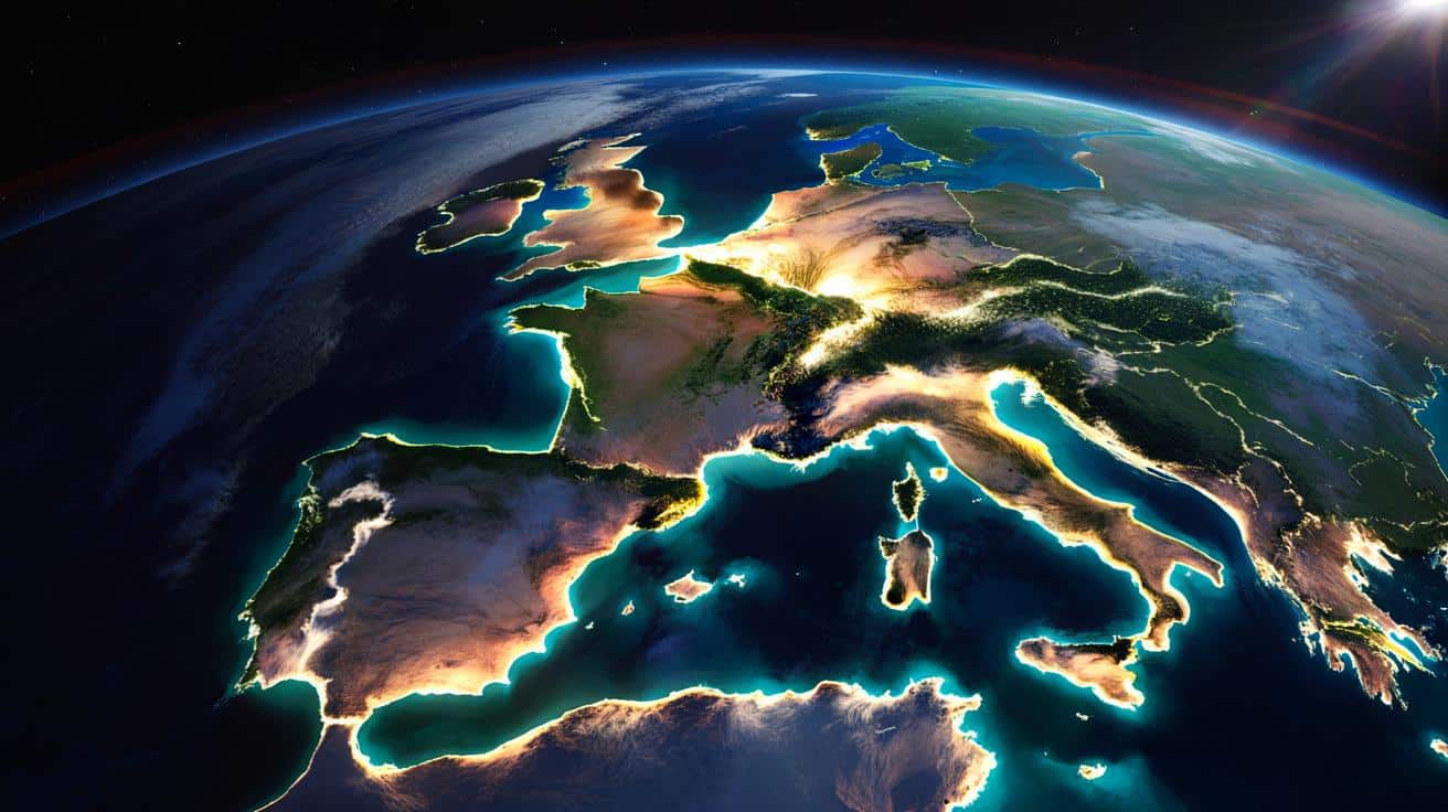
For years, geodynamic models painted a consistent picture: the Iberian peninsula, a microplate carrying Spain, Portugal and part of southern France, rotated gently in an anti-clockwise direction while drifting relative to Africa and the rest of Europe. That neat story just received an update.
Using high-precision satellite positioning, geodetic strain data and records from past earthquakes, a research team has concluded that Iberia now rotates clockwise instead. The rate is tiny on a human scale, but large enough to reshape how scientists think stress accumulates in the crust from the Pyrenees to Morocco.
The Iberian peninsula still moves, but the sense of rotation has flipped: it now twists clockwise under the push of Africa.
This change does not mean the continent suddenly spun around. Rather, the balance of forces along plate boundaries shifted over millions of years, and the newest measurements capture the current phase of that long dance.
The restless Mediterranean: where plates collide
The Mediterranean sits at a tangled junction of tectonic plates. The African plate keeps pushing north, pressing into the Eurasian plate and into smaller microplates such as Iberia, Adria and Anatolia. That slow convergence, only a few millimetres per year, builds mountains, bends crust and stores elastic energy that earthquakes later release.
Geologists trace the modern setting back to the fall of an ancient ocean. Around 90 million years ago, at the end of the Cretaceous period, a young basin known as the Alpine Tethys separated the future Europe and Africa. As the North Atlantic began to open, Africa changed course. Instead of drifting away from Europe, it turned and crept towards it.
Subduction zones swallowed the Tethys seafloor. By roughly 30 million years ago, the two continents collided. That collision helped raise the Alps and triggered a broad reorganisation of stress across the region, from the Atlantic margin to what is now the Middle East.
Iberia’s long journey from France to its current home
Iberia played an active role in this story. Before the Atlantic widened, what is now western France lay tightly welded to the Iberian block. As seafloor spreading advanced, a ridge system opened the Bay of Biscay. Iberia detached from central Europe and started to move.
➡️ Here’s how to recharge your social battery without feeling guilty
➡️ Psychology: What Your Hands Behind Your Back Secretly Reveal About You
➡️ Psychologists reveal the three colors most common in people with low self-esteem
➡️ Psychology explains why emotional restraint often develops quietly, without people even noticing it
➡️ Many households waste money by using appliances at the wrong time of day
During this phase, the block behaved as a microplate. It rotated anti-clockwise and drifted towards the south-west. Later, forces within the widening Atlantic and the compressive push from Africa nudged Iberia eastward by roughly 200 kilometres.
That gradual slide squeezed the crust along its northern margin, raising the Pyrenees. South of Iberia, the complex interaction between Africa, Iberia and the surrounding oceanic crust created the curved Gibraltar Arc, where deformation remains intense and poorly understood.
From hugging western France to colliding with Europe and Africa, Iberia has shifted, rotated and crumpled into its present shape over tens of millions of years.
The switch to clockwise rotation
Despite this busy history, geologists still struggled to pin down present-day motions. The broad Africa–Eurasia convergence is well known: the plates approach each other by roughly 4 to 6 millimetres per year. Yet how that motion distributes between Iberia, the Atlantic margins and North Africa remained hazy.
The new study tackles that gap with two main tools: satellite geodesy and seismic stress analysis. Global Navigation Satellite System (GNSS) stations across Spain, Portugal, southern France and north-western Africa provide precise velocities for dozens of locations. At the same time, earthquake focal mechanisms, which show how faults slipped during past quakes, reveal local stress directions.
Combining these datasets, researchers calculated how the crust stretches, shortens and shears. The patterns line up with a subtle but consistent clockwise twist of the Iberian block relative to stable Eurasia.
Why the direction changed
The team points to the distribution of compressive forces along the plate boundary. West of the Strait of Gibraltar, Africa now pushes almost directly into Iberia across the Atlantic contact. East of the strait, around the Gibraltar Arc, the crust absorbs much of that force through complex deformation, subduction remnants and faulting.
This asymmetric loading steers the peninsula, causing a slow clockwise rotation centred roughly beneath the interior of the Iberian plate. That rotation changes how and where stress accumulates, especially near the Pyrenees and along southern faults crossing Spain and offshore areas towards Morocco.
- North of Iberia: compression builds along parts of the Pyrenees and Cantabrian margin.
- South of Iberia: mixed compression and strike-slip motion affects the Gulf of Cádiz and Gibraltar Arc.
- Interior of Iberia: strain stays low but not zero, with minor deformation spread over a wide area.
What this means for earthquake risk
The Mediterranean has produced major historical earthquakes, from Lisbon in 1755 to destructive events in Algeria, Greece and Turkey. Many faults that slice through the crust remain poorly mapped or only partially understood. Any refined picture of how plates move helps sharpen regional hazard assessments.
The updated motion model points to zones where stress focuses, helping identify faults that might host future damaging earthquakes.
In the Pyrenees, the clockwise rotation changes previous assumptions about how quickly some faults load. Although this mountain belt seems quiet compared to more active regions, paleoseismic data show a record of significant quakes over thousands of years. A better handle on local stress orientation helps estimate which segments could rupture next.
Around the Strait of Gibraltar and the Alboran Sea, the results support a view of very complex deformation, with overlapping compression, extension and sideways sliding. This complexity matches patterns seen in offshore seismic surveys and historical records of tsunamigenic earthquakes in the eastern Atlantic.
Key regions to watch
| Region | Dominant tectonic behaviour | Implication for hazard |
|---|---|---|
| Pyrenees | Crustal shortening with reactivated faults | Moderate but non-negligible seismic risk on long timescales |
| Gulf of Cádiz | Compression and strike-slip near Africa–Iberia boundary | Potential for offshore earthquakes and tsunamis |
| Gibraltar Arc / Alboran Sea | Complex deformation, remnants of subduction | Hard-to-predict seismic behaviour, need for dense monitoring |
| Iberian interior | Low, distributed strain | Lower hazard, but infrequent moderate events remain possible |
How satellites track a continent’s slow twist
The shift in Iberia’s rotation direction does not come from a single instrument. Researchers rely on a dense network of geodetic stations tied to global reference frames. Many points are embedded in bedrock, continuously recording signals from GNSS constellations.
Over years, even millimetre-scale motions become visible. When scientists subtract broader plate motions and filter out local noise such as groundwater or seasonal loading, a coherent regional pattern emerges. Seismic data then fill in the gaps, especially in offshore areas where ground stations remain sparse.
These methods have transformed tectonic research. Instead of inferring current motions only from ancient rocks and plate reconstructions, geologists now watch the crust move almost in real time. For regions like Iberia, where historical earthquakes raised concern but mechanisms stayed fuzzy, that difference matters for planning and risk management.
Why a microplate’s behaviour matters beyond Iberia
Iberia offers a natural laboratory for collision zones that involve both big plates and smaller continental blocks. Similar microplates exist beneath the Aegean region, the Caribbean and parts of Southeast Asia. In many cases, they sit near densely populated coasts or major cities.
Understanding how stress transfers across a microplate and how rotation changes over time can improve long-term forecasts of where crust will thicken, where basins will open and where mountain belts might reactivate. Those insights feed into models of sea-level change, sediment delivery, resource distribution and even long-range infrastructure planning.
The Iberian case also shows that tectonic behaviour does not stay fixed. A region that once rotated anti-clockwise can gradually switch direction as subduction zones shut down, new faults form and distant plate boundaries shift their pull and push.
Looking ahead: models, simulations and everyday impact
Researchers now plan to plug the new motion data into sophisticated computer simulations of the western Mediterranean. These models couple surface deformation with deeper mantle flow, tracking how slabs of old oceanic crust sink and how their movement bends the overlying lithosphere.
Simulations can test scenarios such as: how will stress patterns change if convergence between Africa and Eurasia speeds up slightly, or if deformation localises onto a smaller number of major faults south of Iberia? These questions might sound abstract, but they tie directly to how risk maps evolve over coming decades.
For people living in Spain, Portugal, southern France or northern Morocco, the daily consequences remain subtle. Buildings do not suddenly crack because a microplate turned clockwise. Yet urban planners, insurers and engineers rely on the underlying science when setting building codes or designing key structures like dams, bridges or nuclear facilities.
This new view of Iberia’s motion also feeds into educational and tourism projects. Geological trails in the Pyrenees or along the Portuguese coast can now tell a slightly different story: the land visitors walk on still turns, just in the opposite direction from what textbooks once said. That simple twist helps make deep time and active geology feel a little more real.